
Winter Storm Warning For Minnesota: What You Need To Know About Snowfall And Safety
- Leave a Comment
- James M
- December 19, 2024

On its approach to Minnesota, a powerful winter storm is expected to reach late Wednesday and last into Thursday. It is anticipated that this storm will produce a significant amount of snow—up to seven inches in certain places. As it moves eastward, the system will impact the entire state after moving in from the northwest. This snowstorm may be the largest of the season and perhaps the most important since last winter, according to forecasters. It’s critical to remain vigilant and get ready for potentially dangerous situations because of the mix of heavy snow, high gusts, and cooler temperatures.
The snow will get heavier as the storm moves in, particularly during the Thursday morning commute, with central Minnesota seeing up to an inch of snowfall per hour. It is anticipated that the winter storm would impede travel throughout the state, making it hazardous and challenging. Strong wind gusts might impair vision and cause roads to become slick and blanketed in snow, which would increase the risk of accidents. The severity of the upcoming weather is indicated by the fact that the National Weather Service has already issued winter storm warnings for a number of areas.
It’s important to stay informed during the storm because things are predicted to get worse quickly. Residents can better predict how the storm will affect their everyday routines by keeping an eye on local weather reports and knowing when it is expected to occur. It’s crucial to make plans in advance and modify schedules because snow is expected to persist until Thursday, particularly for those who are traveling or commuting. Being aware of the storm’s possible intensity can help you decide if it’s safe to leave the house.
In order to stay safe during a snow storm, preparation is essential. Being proactive now will have a big impact, from winterizing your car to keeping emergency supplies on hand. Being ready for the storm’s potential effects, such as power outages, travel delays, and hazardous road conditions, will help you stay comfortable and safe. Much of Minnesota will be affected by this winter storm, so it’s critical to be aware of how to adapt to the changing conditions to keep yourself safe and cause the least amount of disturbance.
Overview of the Storm
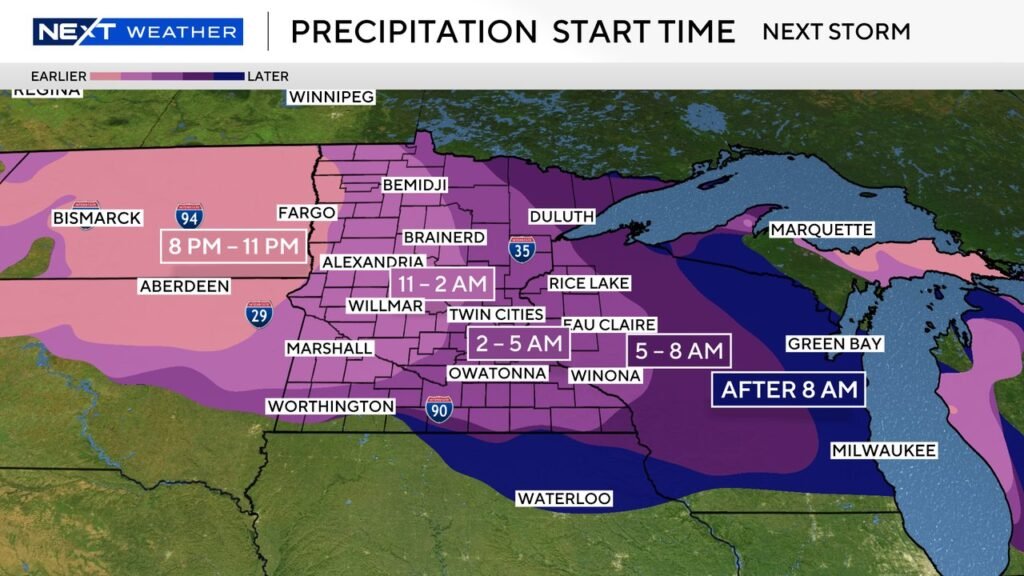
Late Wednesday night is when the impending winter storm is predicted to hit Minnesota, bringing with it severe winds and a lot of snow. Around 8 p.m., snow will start to fall in northern Minnesota as the system comes in from the northwest. It will spread over the state by tonight, and by Thursday morning, snow will be falling in the central and southern regions. According to meteorologists, the snow will continue to build up and affect both urban and rural areas, making Thursday a difficult day to travel. As the storm develops, it’s critical to keep up with developments and stay informed.
Snowfall is predicted to continue throughout the day and then taper off Thursday night into early Friday morning as the storm continues through Thursday. This might be one of the biggest snowstorms of the winter, according to WCCO meteorologist Joseph Dames. He stresses that dangerous conditions will arise, particularly during the Thursday commute, due to the accumulation of snow and the possibility of severe winds. Drivers need to be ready for slick weather, reduced visibility, and roads coated in snow. Snow will get heavier as the storm continues throughout the day, so it’s important to exercise caution.
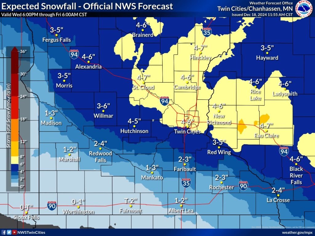
By the end of Thursday, it is anticipated that many places would receive several inches of snow, with some northern areas perhaps receiving up to seven inches. Since the busiest morning and evening commutes will coincide with the greatest snowfall, the timing and intensity of this winter storm make it a very significant event. A snow storm warning has been issued by the National Weather Service, urging locals to anticipate poor visibility and hazardous driving conditions. People may reduce interruptions and guarantee their safety throughout the storm by keeping informed and modifying preparations as necessary.
Late Thursday night, the storm will finally slow down, and by Friday morning, the snowfall will stop, leaving behind a layer of snow and chilly temperatures. But even as the storm passes, problems could still arise in the aftermath. Commuters should be aware of slick areas and remaining snowbanks, and snow clearing activities will be crucial. Joseph Dames says that even though this storm won’t linger long, it’s worth keeping an eye on because of its timing and strength. As the storm moves throughout Minnesota, it’s critical to remain ready for severe conditions.
Snowy Surprise: A man in Utah captured a rare 'snownado' swirling near him while walking his dogs during a winter storm. ❄️🌪️ pic.twitter.com/tP2i4tbDyk
— AccuWeather (@accuweather) December 18, 2024
Warning of a Winter Storm
In anticipation of a significant winter storm, the National Weather Service has issued a Winter Storm Warning for a number of areas in Minnesota and Southeast North Dakota. The warning will be in force from Wednesday at 9 p.m. to Thursday at 6 p.m. The most severe effects will be felt in southeastern North Dakota and northwest and west-central Minnesota. Strong gusts and a substantial amount of snow are predicted for this storm, which could make travel dangerous and impair visibility. As the storm continues to strengthen into Thursday, residents in the impacted areas should be ready for hazardous weather conditions.
With possible accumulations of 3 to 7 inches, cities in northwest and west-central Minnesota are predicted to have some of the highest snowfall totals. Driving conditions will be difficult as the snow starts to fall on Wednesday night and covers the roadways by Thursday morning. The most significant precipitation is expected to fall in places like Ashby, Moorhead, and Fergus Falls, and the buildup of snow is expected to produce traffic jams and delays all day long. People should pay close attention to the weather and traffic conditions during the Thursday morning commute, as this is when the storm’s strength is predicted to reach its peak.
With winds of up to 40 mph, southeastern North Dakota cities like Fargo, Wahpeton, and Valley City will also experience heavy snowfall totals. Road visibility will be further reduced by blowing snow brought on by these strong gusts. It will become riskier to travel, particularly on untreated roads, and accidents might happen more often. Because the storm will be at its strongest between 9 p.m. Wednesday and 6 p.m. Thursday, the National Weather Service recommends locals to avoid driving as much as possible. Drivers should be ready for ice conditions, snow-covered roadways, and the potential for power outages.
The snow will remain in these locations for the majority of the day, but Thursday evening the storm will gradually taper down as it heads eastward. Residents of Ashby, Fargo, and Moorhead should prepare for decreased visibility, slick roadways, and possible interruptions to their regular routines. Residents are advised to take the appropriate preparations, such as ensuring their cars are prepared for winter conditions and storing up on emergency supplies, and to stay informed by following local weather updates while the Winter Storm Warning is in effect. Planning beforehand and being ready for the effects is crucial because the storm is anticipated to leave behind a lot of snow and difficult travel conditions.
A man in Utah captured a rare 'snownado' swirling near him during a winter storm while out walking his dogs. pic.twitter.com/o8GiwxsHhh
— Fox News (@FoxNews) December 19, 2024
Depending on the area, Minnesota’s snowfall forecast shows a variety of anticipated accumulations. From Wednesday evening through Thursday evening, residents of the Twin Cities should anticipate 2 to 4 inches of snowfall. The snowfall is expected to be consistent but not as heavy as in other areas of the state. Traveling on Thursday would be more challenging due to slick roads and low visibility caused by the mix of snow and strong winds. with the metro area, drivers should be on the lookout for shifting conditions and be ready for roads blanketed with snow and with less visibility.
Snowfall in Southwestern Minnesota is projected to be minimal, with most places receiving less than 1 inch. Although there will be some snowfall in the area, it won’t be as severe as it would be in the state’s north and center. Even if there won’t be much precipitation, locals should nevertheless prepare for the chance of ice roadways, especially in the evening when temperatures are predicted to dip. Despite the spotty snow accumulation, vehicles should exercise caution, particularly on untreated and country routes.
A more erratic snowfall forecast is anticipated for southeast Minnesota, with regions receiving ranging from a trace amount to four inches of snow. The system will deliver light snow to the area, but if the storm stays longer in some places, the totals may be a little higher. The storm could still bring strong wind gusts of up to 40 mph, which could result in blowing snow and dangerous traffic conditions even if there will be comparatively less snowfall. Due to strong gusts, drivers in the state’s southeast should be aware of snow drifts and abrupt changes in road conditions.
Central Minnesota, especially north of Interstate 94, is predicted to receive the most amounts of snowfall. Three to six inches of snow are predicted here, with higher accumulations likely expected in some places if the storm gets stronger. The system as a whole is predicted to bring the most snow to this area, and the combination of precipitation and strong winds will make conditions extremely dangerous. The high winds will cause drifting snow and poor visibility, and the roads will probably be sloppy and coated in snow. Residents should be informed about weather alerts and prepare for challenging driving conditions in certain places, where wind gusts can reach 40 mph.
In the Red River Valley in northwest Minnesota, the winter storm is predicted to begin Wednesday between 8 and 11 p.m. By late tonight, snow will start to fall steadily and spread over the state, impacting both rural and urban areas. The snow will get heavier during the night as the cyclone shifts east, making Thursday’s morning commute difficult. As the snow starts to build up, drivers should be ready for roads blanketed in snow and decreased visibility.
As the storm intensifies, the pace of snowfall will rise. In certain places, especially in the Red River Valley and central Minnesota, snow will be falling at a pace of roughly ½ inch per hour during the Thursday morning commute. One inch of snow is expected to fall each hour in central Minnesota as the storm gets stronger. Travel will be challenging as a result of the snow rapidly building up on the roads and perhaps creating hazardous driving conditions. On Thursday, the snow will keep falling all day long, with the morning hours—especially between 6 a.m. and noon—seeing the most snowfall.
Although snowfall will continue throughout the day, it will start to lessen in severity by Thursday afternoon. Snow will continue to fall in certain areas of Minnesota until late Thursday night as the storm system travels eastward. During this time, winds will increase, resulting in blowing snow and further decreasing visibility, particularly in regions that are more exposed. Road conditions will continue to be hazardous as snow builds up, and drivers are urged to use caution when commuting in the evening.
By Thursday evening or early Friday morning, the storm will progressively weaken, and as the system leaves the state, the snowfall will stop. Travelers should exercise caution even if the storm’s worst is past because snow clearance works are still ongoing and there are still slick patches on the roads. Throughout the day, snow will have piled, creating plowable snow and potentially dangerous conditions at night.
Due to the impending snow storm, Minnesotans are advised to be ready for major travel delays on Thursday, as a Next Drive Alert is in force for commutes. Conditions will deteriorate during the morning hours of Wednesday as snow starts to fall overnight. Driving will be exceedingly dangerous due to the roads being blanketed in snow and the decreased visibility. Increased snowfall rates, especially in central Minnesota, will make travel more challenging, especially during the morning commute. To ensure they get to their destinations safely, those who have to travel on Thursday should prepare for lengthier drive hours.
Roads will be completely blanketed with snow, according to the medium travel impact level. Additionally, the storm’s combination of snowfall and wind gusts may result in blowing snow, which would further impair visibility. Even on major routes, drivers may come upon icy and slick weather. This increases the likelihood of collisions and accidents, particularly on secondary or untreated routes. Drivers must modify their speeds and keep a safe following distance as the snow continues to build up in order to prevent crashes and losing control.
In addition to roads blanketed in snow, travel becomes even more dangerous due to drifting snow caused by wind gusts of up to 40 mph. In certain places, especially in open and rural areas, visibility will be almost nonexistent due to these winds and the heavy precipitation. Road conditions can change quickly, and drivers should be ready for large snow drifts or ice patches. Avoiding travel during the storm’s peak hours is advised, particularly if the predicted snowfall or visibility rapidly deteriorates.
There are a few things to remember if you have to drive during a storm. First, make sure your car has enough windshield wipers, healthy tires, and working lights for the winter. Keep a flashlight, blankets, non-perishable food, and water in your emergency kit at all times. Drive conservatively and slowly, especially when crossing bridges and overpasses that freeze more quickly. Lastly, to increase your visibility and that of others, keep your headlights on. During this potentially dangerous winter storm, risk can be reduced by being informed and making necessary adjustments to travel plans.
It’s critical to keep up with the most recent weather updates and alerts as the winter storm draws near. You may stay up to date on the storm’s development and any modifications to its schedule or strength by keeping an eye on your favorite weather app, the National Weather Service, or local weather stations. You can better prepare for the biggest effects, such as potential road closures, school cancellations, or adjustments to public services, by keeping an eye on Next Weather Alerts. By keeping yourself updated, you can make proactive choices regarding your employment, travel, and other plans, making sure you’re prepared to adapt to changing circumstances.
Winterizing your car before the storm arrives is another crucial preparation advice. Make sure your tires are appropriately filled and prepared for winter driving, particularly if you’re traveling through regions that are predicted to experience significant snowfall. Since snow and ice may quickly impair vision, make sure your windshield wipers are in good working order. A flashlight, blanket, non-perishable snacks, and extra gloves are all necessary items to keep in your car’s emergency kit. You’ll be more equipped to wait for assistance or deal with unforeseen delays in a safe manner if you do end up stuck.
Planning for delays is crucial because the forecast calls for heavy snowfall and poor visibility. Allowing additional time for travel is crucial, whether you’re picking up groceries, going to appointments, or traveling to work. Due to snow-covered roads and the possibility of slower traffic, particularly during peak commute hours, longer drive times are anticipated. If at all possible, try to avoid traveling during the storm’s strongest periods by modifying your schedule or working from home. By allowing yourself more time, you can negotiate winter circumstances more safely and with less stress.
Lastly, stock up on emergency supplies in case of power interruptions. Some communities may lose electricity as a result of downed power lines caused by the storm’s strong winds and heavy snowfall. In case of a prolonged outage, it’s a good idea to keep supplies like blankets, flashlights, batteries, and non-perishable food on hand. To make sure you can stay in contact with loved ones, friends, and emergency services in case of an emergency, you should also make sure your mobile devices are fully charged before the storm. You and your family will be safer and more comfortable during the winter storm if you follow these precautions.
Conclusion:
Prioritizing safety during the event is essential as the winter storm approaches Minnesota. Road conditions will be dangerous due to the combination of heavy snow, strong winds, and poor visibility; the possibility of power outages adds even more risk. Being cautious when traveling, remaining at home when you can, and making sure your house and car are prepared for the storm’s effects are all part of being safe. It’s usually preferable to err on the side of caution because, in winter, even minor mishaps or delays can become out of hand.
It’s critical to remain educated and adaptable as circumstances change throughout Thursday. Conditions might rapidly deteriorate, especially during periods of high travel demand, and the forecast is subject to change. Before you go, check the road conditions and weather forecast, and be ready to change your plans if needed. A smoother experience during this winter storm can be achieved by taking precautions to be informed and prepared, whether you’re staying at home, performing errands, or commuting.
You may safely and confidently navigate the storm by being aware and taking the appropriate safeguards. Although Minnesota’s winter weather might be erratic, you can reduce its effects and be safe if you prepare. As the storm draws near, be vigilant, be organized, and most importantly, be safe.