
As A Major Snowstorm Approaches, Chicago Schools Have Closed: What You Need To Know
- Leave a Comment
- James M
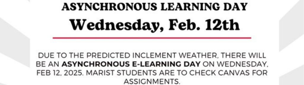
- February 12, 2025
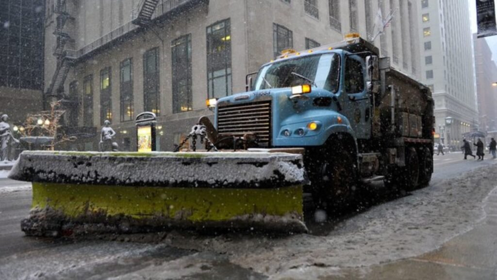
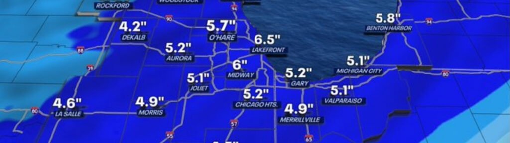
Chicago is bracing for a huge winter storm that will bring heavy snow, terrible traffic, and the closure of numerous schools. With 3 to 6 inches of snow forecasted, numerous schools in the Chicago area have closed or transitioned to E-learning to ensure students and staff’s safety.
There will be a Winter Weather Advisory from 9 a.m. Wednesday to 3 a.m. Thursday, warning individuals about hazardous visibility, slippery roads, and hazardous driving conditions. Drivers should expect a tough ride on Wednesday afternoon and evening as the storm intensifies. It may snow as much as one inch per hour. As Chicago weathers this winter storm, stay informed about school closures, weather, and road conditions.
As a significant winter storm hits the Chicago area, numerous school systems have closed or transitioned to E-learning on Wednesday, February 12, 2025. With 3 to 6 inches of snow forecasted and hazardous travel conditions predicted, administrators are weighing the safety of children, staff, and families.
Lyons Elementary School District 103, St. Edward Central Catholic High School, Joliet Public Schools District 86, and Troy 30-C School District are only a few schools that have transitioned to online learning. Some school districts, such as Troy 30-C, have announced a total emergency day with no classes or e-learning. Other districts, such as New Lenox School District 122, have provided children with e-learning activities to do at home.
The National Weather Service states there will be a Winter Weather Advisory from 9 a.m. Wednesday until 3 a.m. Thursday. They also state the snow will be heaviest from 11 a.m. to 5 p.m. Snowing an inch an hour will be hard to spot because it accumulates quickly. Many schools had to shut down due to these hazardous conditions. Schools are making every effort to keep kids, teachers, and parents safe during the most traveled times of the day.
Several school districts have instructed families to stay off the roads unless they have to venture out and to check local news for additional weather updates and potential extended school closures. Another winter storm is possible this weekend, so officials and residents are still being extremely cautious about additional issues. Parents and students can check their school district’s website to check out special e-learning instructions, homework, and schedules.
The winter storm that will hit Chicago is predicted to begin early Wednesday morning and leave light snow over the area. The early rain will be fine, but the storm will be picking up during the day. The morning commuters should expect slippery roads, but the worst traffic will be later in the day.
The snow will pile up a lot by late morning and early afternoon. The most intense snow will be from 11 a.m. to 5 p.m. Up to an inch of snow may fall per hour, so roads and sidewalks will become very slippery very quickly. The amount of snow forecast is 3 to 6 inches, and this will be hazardous to drive everywhere in the Chicago area.
Drivers can expect lower visibility, slippery roads, and potential delays, particularly in the evening. The National Weather Service has cautioned that snow will fall quickly so that non-plowed roads may become hazardous in minutes.
When Thursday morning comes, the storm will be over, and the region will be dry. Temperatures, however, are forecast to plummet to the teens and low 20s, a dramatic plunge. Since it will be that cold outside, any lingering snow and slush will have a good chance of freezing, creating ice patches on roads and sidewalks that are not plowed.
While the morning commute should be better than Wednesday nights, drivers should be careful because there may still be icy spots. As the city digs out of the storm, snowplows and salt trucks will continue to clear the main roads. Side streets and less-traveled roads can still be slippery well into the morning, however.
The Chicago blizzard is expected to render driving unsafe, particularly during the evening and afternoon of Wednesday, when between an inch and an inch of snow can fall in an hour. The quickly falling snow will render roads slippery, lower visibility, and increase the risk of accidents, making travel extremely perilous.
Even cleared roads, according to the National Weather Service, become slippery due to the continuous snowfall. Untreated roads are undriveable. Travelers should anticipate delays, crawling traffic, and even closed roads, particularly in areas where snow clearing will be longer.
The authorities firmly recommend that individuals stay away from roads unless it is unavoidable due to the expected poor road conditions. In case travelers have to venture out, they must be very cautious since heavy snowfall will severely lower visibility.
Important safety measures to prevent accidents are to drive slowly, give more space between vehicles so that they can be stopped, and avoid sudden turning or braking.
Individuals using public transport should anticipate delays and give themselves extra time for their travel since snow on roads may hinder bus and train schedules.
Drivers should stock an emergency kit in case of delays or breakdowns of cars. The kit should contain a charged cell phone, spare clothing, beverages, snacks, a flashlight, and ice scraper, and a small shovel. High-octane gas and a tire tread check can make you safer during winter.
A new beginning for the Eagles, who won their second Super Bowl. Hurts is the best quarterback in the NFL. Nick Sirianni has shown that he is a great coach. In Philadelphia, as a top-tier team for the franchise, a win takes away the pain of losing Super Bowl LVII.
Checking road conditions and weather forecasts during the storm is also very crucial. Travelers may consider an alternate route or delay trips until the weather is better.
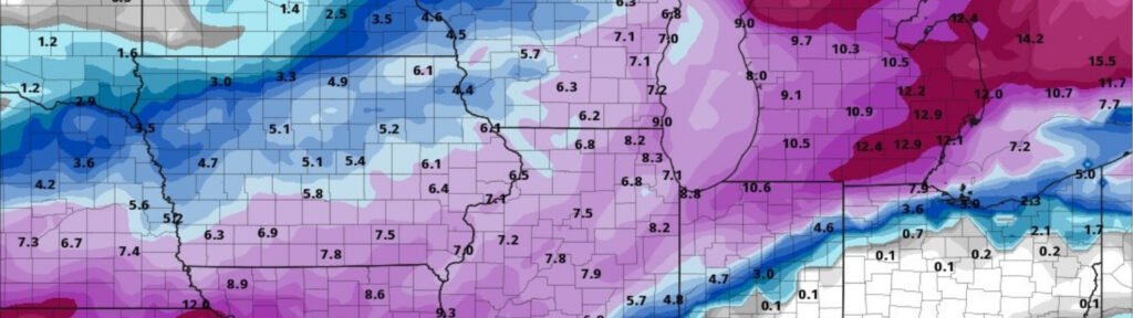
As Chicago recovers from the winter storm on Wednesday, meteorologists are already looking to this weekend to determine whether another storm will strike the Midwest.
Though details are uncertain, meteorologists caution the next storm could deliver more snow, heavy bursts of wind, and freezing temperatures that could make traveling and everyday life more challenging again. As the weather continues to change, people should listen for further updates.
Even a light dusting of snow over what was received on Wednesday could make sidewalks and roads dangerous if not treated.With two back-to-back winter storms, residents in the Midwest need to be prepared for quickly changing weather.
The National Weather Service advises having food, beverages, flashlights, additional blankets, and backup power sources in case of power outages during winter.
If driving is unavoidable this weekend, checking weather warnings and road conditions beforehand is necessary to remain safe. Individuals who have travel plans this weekend should have backup plans or delay their trips in case the storm intensifies.
In preparation for this potential storm this weekend, it will be necessary to monitor forecasts from trusted weather sources. As meteorologists continue to make more accurate predictions, individuals should monitor local news, weather apps, and emergency notifications to ensure that they have the most up-to-date information. Winter weather is still impacting the region, so caution and preparation will be necessary to remain safe in the coming days.
The Chicago region is preparing for a massive winter storm on Wednesday. The heavy snow will be hazardous to drive in and close schools throughout the area. The most intense snow will fall between 11 a.m. and 5 p.m., at the rate of up to 1 inch per hour, making it difficult to see because the snow will accumulate rapidly. By Thursday morning, streets that have not been plowed can still be hazardous due to the cold and ice that still linger.
Families must stay informed about school closures and e-learning adjustments as winter weather impacts the region. Families have to monitor local weather reports regularly to check in and plan accordingly. There is potentially another storm this weekend, so individuals are asked to be careful and have backup supplies ready.
Safety has to be the priority. Avoid driving during the peak of the storm if possible, and adhere to winter driving safety guidelines. Prepare, stay safe, and be prepared for whatever occurs in the next few days.