
Magnitude 5.2 Earthquake Hits Southern California: What You Need To Know
- Leave a Comment
- James M
- August 7, 2024
A noteworthy seismic event occurred in Southern California on August 6th evening when a magnitude 5.2 earthquake shook the region.
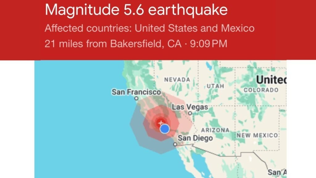
The earthquake struck at 9:09 p.m. local time and was centered in the sparsely populated Kern County area, some 18 miles southwest of Bakersfield.
Aftershocks from this earthquake, which was first recorded at a magnitude of 5.3, continued for some time. One notable one struck less than a minute after the main event and had a magnitude of 4.5.
The earthquake’s epicenter was around 60 miles northwest of Santa Clarita and 14 miles northwest of Grapevine, an unincorporated settlement.
This earthquake caused seismic waves that were felt in several parts of Southern California, including Bakersfield, Santa Clarita, and Ventura.
Even though the shaking was felt over a large area, no significant damage was reported right away.
Following the earthquake, those in denserly inhabited areas reported mild shaking, while people nearer the epicenter reported stronger sensations.
The incident has emphasized how crucial it is to comprehend California’s seismic threats and how successful early warning systems are at giving people advance notice of these kinds of occurrences.

Information about the Earthquake
On August 6, 2024, at precisely 9:09 p.m. local time, an earthquake occurred in Southern California. The United States Geological Survey (USGS) later altered the initial magnitude of the seismic event from 5.3 to 5.2.
With this magnitude, it falls into the category of moderate earthquakes, which can nevertheless cause some modest damage and visible shaking, especially if they happen close to inhabited areas.
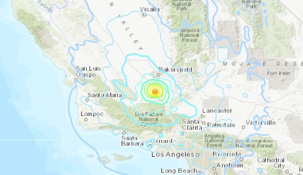
The majority of Kern County is rural, and the epicenter of the earthquake was located about eighteen miles southwest of Bakersfield.
This place is roughly 60 miles northwest of Santa Clarita and 14 miles northwest of the unincorporated settlement of Grapevine. From this location, the seismic waves spread outward, impacting a large portion of Southern California.
The fact that the earthquake was felt in so many different cities—Bakersfield, Santa Clarita, Ventura, among others—shows how widespread its effects were.
A series of aftershocks, which are typical during large seismic occurrences, were felt in the area shortly after the main shock. With a magnitude of 4.5, the first significant aftershock happened less than a minute after the initial earthquake.
At 9:17 p.m., a magnitude 4.1 aftershock was detected, adding to the overall seismic activity felt by locals and prolonging the period of shaking.
The distance from the epicenter to the shaking’s center determined how strong it was. Stronger vibrations were felt in areas closer to the epicenter, such Grapevine and the surrounding areas, while milder tremors were detected in areas farther away, like Bakersfield and Ventura.
Geological conditions, the local amplification of seismic waves, and the distance from the epicenter are some of the elements that affect this difference in shaking strength.
#UPDATE: The earthquake was downgraded to a magnitude 5.2. LAFD confirms no significant infrastructure damage or injuries have been noted within the City of Los Angeles. Mayor Karen Bass said emergency teams will continue to monitor any impacts.
— KTLA (@KTLA) August 7, 2024
Details: https://t.co/I4hjevoqfU pic.twitter.com/23aueKwfyY
Impact & Direct Consequences
The impacts of the shaking were most noticeable in the vicinity of the epicenter of the earthquake, but they varied significantly throughout Southern California.
Grapevine and other areas nearest to the epicenter saw “very strong” shaking. There were visible disruptions and large vibrations that shook structures during this strong shaking.
On the other hand, only “weak” shaking was felt in farther-off places including Bakersfield, Santa Clarita, and Ventura. This was enough to create small vibrations in buildings and minor swaying of standing cars.
A big boulder obstructing many lanes on Interstate 5 caused a traffic interruption, which was one of the earthquake’s more noticeable and immediate effects.
About a mile south of Grapevine Road, it was reported that the boulder, which was roughly the size of an SUV, was obstructing southbound traffic.
Traffic was severely delayed as a result of this obstacle, and it took a long time for highway maintenance workers to remove the debris.
The bottleneck demonstrated the disruption brought on by the seismic activity as it remained in place for at least an hour following the quake.
There were some visible tremors and traffic problems, but no initial reports of significant earthquake damage were received.
According to preliminary assessments, there was no major structural damage reported in the impacted districts, despite a few small delays and inconveniences like the traffic congestion.
The mild magnitude of the earthquake and the fact that it happened in an area with different building rules and construction practices are contributing factors to the relative lack of damage.
The early warning systems’ prompt action and the lack of significant damage helped to lessen the earthquake’s possible effects.
Residents may have helped to limit the overall amount of immediate damage since they were able to prepare for the shaking after receiving timely signals from the USGS’s earthquake early warning system.
The significance of readiness and the efficiency of early warning systems in lessening the effects of seismic events are highlighted by this tragedy.
A significant magnitude 5.2 earthquake occurred just outside of Bakersfield, California 10 minutes ago.
— Colin McCarthy (@US_Stormwatch) August 7, 2024
Did you feel it? pic.twitter.com/sLss5XWBJh
Several factors, such as soil type, building height, and closeness to the epicenter, can dramatically affect the severity of shaking experienced during an earthquake.
Seismic waves are typically amplified more by softer soils than by harder bedrock, such as those found in river valleys or basins packed with silt.
When opposed to regions built on stable rock formations, locations with loose, unconsolidated materials may experience more intense shaking due to this amplification effect.
Furthermore, because of the greater swaying impact at higher floors, taller buildings frequently feel more intense shaking, which might worsen the perception of the power of the earthquake.
These criteria can be used to explain the difference in shaking intensity that occurred over Southern California following the recent magnitude 5.2 earthquake.
Stronger and more pronounced shaking was felt in the vicinity of the epicenter, especially in areas with weaker soil. On the other hand, areas that were situated farther away from the epicenter or on more stable terrain experienced less tremors.
The local environment’s geological features were a major factor in deciding how powerfully the earthquake was felt in various places.
Seismic amplification effects are particularly well-known in the Los Angeles Basin. This basin is a deep, mountain-encircled depression that is full of weak sand and gravel and filled with sediment.
Seismic waves that enter this basin are reflected back by the walls of the basin and cause increased shaking, which can greatly extend the duration and intensity of the seismic effects.
The “basin effect” refers to the fact that, in comparison to other places with distinct geological characteristics, even moderate earthquakes can cause more apparent shaking in the basin.
The more intense shaking that locals experience is a result of the Los Angeles Basin’s increased seismic waves. Consequently, even though the earthquake’s magnitude may be regarded as mild, the impacts within the basin may give the impression that it is more strong.
Comprehending the amplification effects of earthquakes is essential for evaluating their implications and planning for future seismic events, especially in areas with comparable geological circumstances.
Residents in earthquake-prone areas can receive timely alerts thanks in large part to the USGS earthquake early warning system. In order to identify the early, less-destructive seismic waves (P-waves), which travel more quickly than the more destructive waves (S-waves) of an earthquake, this method makes use of a network of seismometers.
After detection, the system determines the anticipated level of shaking and notifies the impacted locations, providing residents with vital seconds to minutes of warning before the heavier shaking occurs. Giving individuals enough time to take precautions will help reduce the number of injuries and property damage.
Many inhabitants of Southern California received alerts from the USGS’s seismic early warning system on the recent magnitude 5.2 earthquake. Several platforms, such as the MyShake app and automatic notifications for Android devices, were used to distribute these messages.
The early warnings varied in length; some people reported feeling the trembling up to 45 seconds in advance. People were able to get ready for the trembling thanks to this earlier notice, which may have lessened the earthquake’s immediate effects.
The way the locals responded to the earthquake demonstrated how successful these alerts were. Early warnings gave people time to prepare or seek shelter, which probably reduced the number of casualties and property loss.
The prompt notifications additionally enabled companies and infrastructure managers to execute safety measures, including stopping trains or locking up dangerous goods, thereby reducing the likelihood of serious injury.
The recent Southern California earthquake of magnitude 5.2 offers a chance to consider the region’s seismic past, especially in light of the noteworthy Kern County earthquake of 1952.
With a magnitude of 7.5, the July 21, 1952 earthquake is still regarded as one of the most significant seismic occurrences in California history.
This strong earthquake, which was located roughly 12 miles southeast of the epicenter of the most recent one, resulted in significant damage and 12 recorded fatalities.
Communities including Tehachapi, Bakersfield, and Arvin were heavily affected by the earthquake, which resulted in structural failures and major disruptions.
The White Wolf fault, a significant fault line in the area well-known for its seismic activity, was linked to the 1952 incident.
The potential for severe seismic activity on the region’s major fault lines was emphasized by the 1952 earthquake, in contrast to the recent 5.2 magnitude earthquake, which was not connected to any previously mapped faults.
The significant destruction caused by the 1952 earthquake, which included significant harm to infrastructure and structures, highlighted the dire repercussions of high-magnitude earthquakes in this region.
The complex network of fault lines that make up Southern California’s seismic history includes the San Andreas and White Wolf faults, both of which are noted for their capacity to cause large-scale seismic events.
The movement of tectonic plates and the interactions between these fault lines affect the seismic activity in the area.
Even while the most recent earthquake in the region, measuring 5.2, was smaller and less destructive than the one that struck in 1952, it nevertheless serves as a reminder of the continued seismic threats in the area.
It is essential to comprehend the historical background of Southern California earthquakes in order to evaluate potential hazards in the future and enhance readiness.
The current earthquake emphasizes the significance of ongoing awareness and adaptation in response to evolving seismic dangers, while the 1952 Kern County earthquake continues to be a crucial reference point for assessing the possible implications of seismic activity.
Researchers and emergency planners can more accurately predict and lessen the damage of future earthquakes by looking back at historical occurrences and their consequences.
There is always a risk of earthquakes in Southern California, as evidenced by the magnitude 5.2 earthquake that occurred recently.
Even while there is little probability that this earthquake would immediately cause a much bigger follow-up earthquake, it is possible that it is a forerunner to something stronger.
According to USGS estimations, there is roughly a 1 in 20 probability that this earthquake is a precursor to a more significant one.
While there is a decreasing chance of more large-scale seismic activity in the future, understanding and planning for future hazards requires ongoing observation and research.
Regardless of the size of the earthquake, preparation is essential to reducing its effects. Strong preparation measures must be in place for individuals, communities, and organizations because earthquakes can strike without much notice.
This entails packing emergency kits, securing bulky objects, and organizing evacuation schedules for families or businesses.
A key strategy for lowering the possibility of injury and property damage during an earthquake is educating the public about earthquake safety precautions and making sure that structures adhere to current seismic regulations.
It is impossible to exaggerate the significance of earthquake early warning systems. These devices give users crucial seconds to minutes’ warning prior to the strongest shaking, enabling them to take preventative measures and get ready for the hit.
The efficiency of these systems was proven by the recent earthquake, which helped many inhabitants prepare for the shaking by sending out timely alerts.
To improve public safety and response efforts, these warning systems must be improved and continuously invested in.
All things considered, recognizing and becoming ready for seismic threats is a continuous process that calls for alertness and proactive actions.
The likelihood of a significant aftershock earthquake is still unknown, but community resilience can be increased and the effects of earthquakes are lessened by combining readiness, public awareness campaigns, and efficient early warning systems.
Conclusion:
The August 6, 2024, magnitude 5.2 earthquake that rocked Southern California caused a major upheaval in the area. The earthquake, which was felt all over Southern California, was centered southwest of Bakersfield and was followed by multiple aftershocks.
There was no significant damage reported in the early aftermath of the earthquake, despite the fact that the severity of the shaking varied according to the epicenter’s vicinity and the local geology.
The incident serves as a reminder of the complexity of seismic activity and the value of constant watchfulness and readiness.
The earthquake also demonstrated the value of early warning systems for earthquakes, which gave many locals crucial time to prepare and take preventative measures.
This incident serves as further evidence of the critical need of preparedness and the necessity of having strong strategies for both individual and communal earthquake response.
It is still necessary to comprehend seismic dangers and take precautions to lessen the possible effects of future earthquakes.
It is critical that those who felt the earthquake communicate their observations and experiences with the USGS as part of the response and recovery process.
By sharing your experiences, you enable the USGS to enhance seismic model refinement and data quality, which in turn improves future preparedness and response operations.
Consider sharing your experience with the USGS if you felt the earthquake or saw any consequences in order to help with their ongoing analysis and improve our knowledge of seismic events.
We can all work together to improve our reaction to seismic events in the future by being aware, prepared, and involved in larger monitoring initiatives.