Tropical Storm Erin: Updates and Forecast for the 2025 Atlantic Hurricane Season
Introduction
Tropical Storm Erin, the fifth named storm of the 2025 Atlantic hurricane season, formed in the eastern Atlantic Ocean on Monday, August 11, 2025, just west of the Cabo Verde Islands. As forecasters track its development, Erin is predicted to strengthen significantly, potentially becoming the season’s first hurricane and possibly reaching major hurricane status by the weekend. This article gives an in-depth primer on the latest updates, projected path, and potential impacts of Tropical Storm Erin, based on information from the National Hurricane Center (NHC), AccuWeather, and other reliable sources.
Current Status and Initial Formation
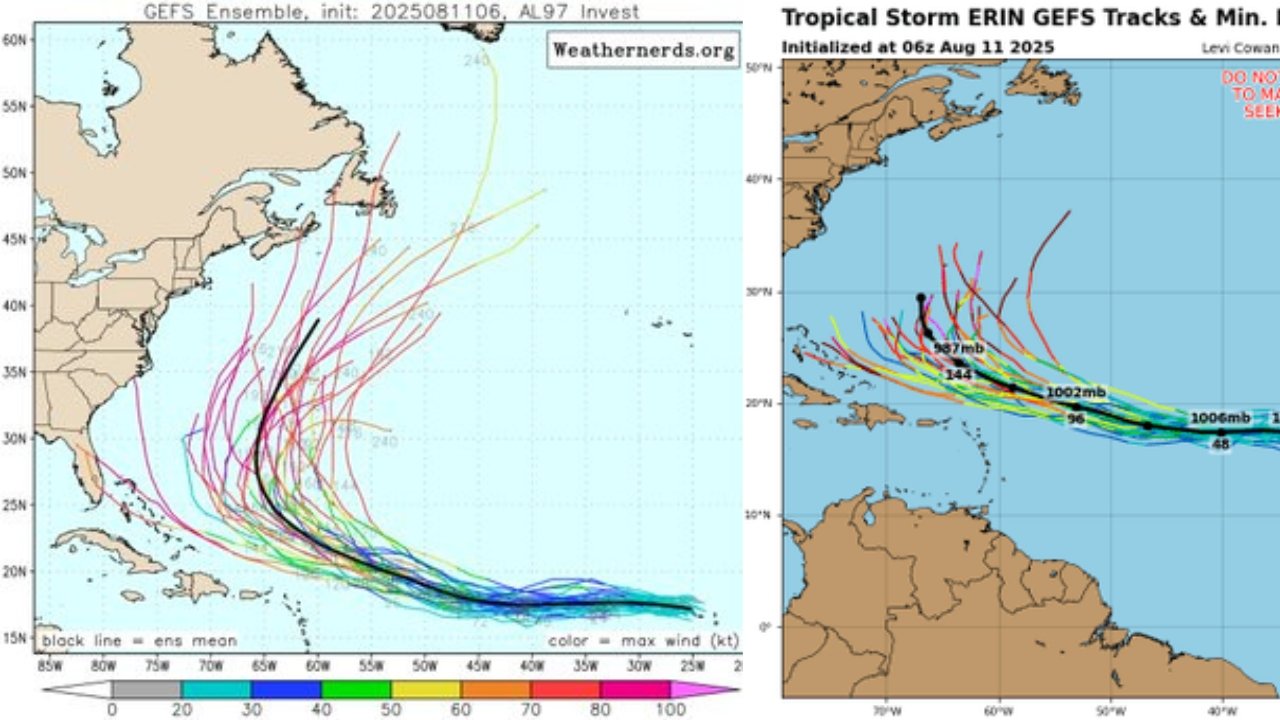
As of 11 a.m. EDT on August 11, 2025, Tropical Storm Erin was located approximately 280 miles west-northwest of the Cabo Verde Islands and 2,305 miles east of the northern Leeward Islands, at coordinates 17.4°N, 28.0°W. The storm has maximum sustained winds of 45 mph, with tropical-storm-force winds extending up to 35 miles from its center, and is moving west at 20 mph. The NHC issued its first advisory at 11 a.m. EDT, noting that Erin formed earlier than the historical average for the fifth named storm, typically around August 22.
Prior to its designation as a tropical storm, Erin was classified as Invest 97L, which brought heavy rain and flooding to the Cabo Verde Islands, causing significant damage to roads and private property. Reports indicate at least six fatalities, including four children, due to severe flooding on São Vicente Island. The Cabo Verde government declared a state of calamity on St. Vincent and St. Anthony in response to these impacts.
Forecasted Path and Intensification
Erin is expected to continue moving west to west-northwest across the eastern and central Atlantic at 15-21 mph over the next several days. Forecast models indicate gradual intensification, with the following projected wind speeds from the NHC as of August 11, 2025:
- 12 hours: 50 mph
- 24 hours: 60 mph
- 36 hours: 65 mph
- 48 hours: 70 mph
- 60 hours: 80 mph
- 72 hours: 90 mph
- 96 hours: 105 mph
- 120 hours: 115 mph
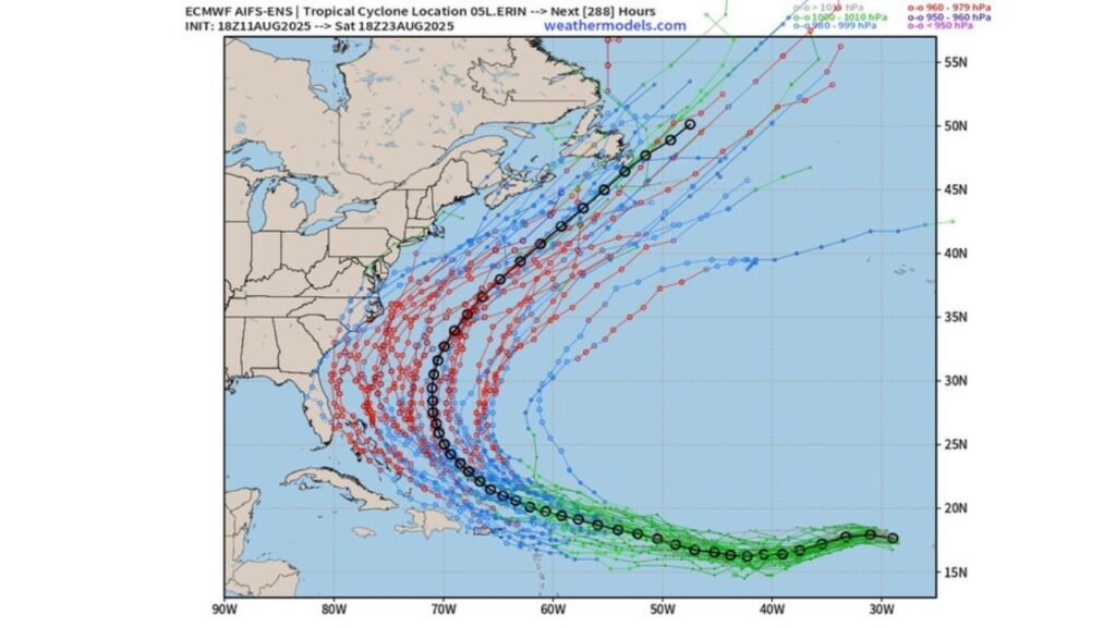
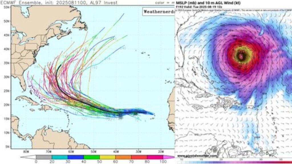
The NHC and AccuWeather predict Erin will reach hurricane status (winds of at least 74 mph) by August 13 or early August 14, potentially becoming a Category 1 hurricane by Thursday afternoon, August 14. By Saturday morning, August 16, Erin is forecast to intensify into a major hurricane (Category 3 or higher, with sustained winds of at least 111 mph), with some models predicting winds up to 115 mph. Warm sea-surface temperatures are expected to fuel this rapid intensification, though short-term wind shear may slow development initially.
The storm’s projected path suggests it will remain north of the Lesser Antilles and the Caribbean by the weekend, with a likely northward turn due to a developing break in high pressure over the Southeast U.S. and east of Bermuda. This turn’s exact timing and location remain uncertain, making it too early to rule out potential impacts on the U.S. East Coast, Bermuda, or Atlantic Canada. However, the probability of a direct strike on the U.S. East Coast is currently low.
Potential Impacts
While it is too early to predict specific landfall impacts, forecasters are urging residents along the U.S. East Coast, Bermuda, and Atlantic Canada to monitor Erin closely. Even without direct landfall, the storm could bring indirect effects such as increased seas, rough surf, and rip currents along East Coast beaches by next weekend into early the following week. AccuWeather has highlighted a “significant increase in seas, surf, and rip currents” as a potential concern.
In the Caribbean, Erin is expected to stay north of Puerto Rico and other islands, reducing the likelihood of direct impacts. However, the storm’s earlier effects on the Cabo Verde Islands serve as a reminder of its potential to cause significant disruption.
The NHC notes that Erin’s small circulation could lead to rapid intensity changes, either strengthening or weakening, depending on environmental conditions like wind shear and sea-surface temperatures. This uncertainty underscores the need for continuous monitoring.
Historical Context and Season Outlook
The 2025 Atlantic hurricane season, which runs from June 1 to November 30, is predicted to be above average, with the National Weather Service forecasting 13 to 18 named storms, of which 5 to 9 could become hurricanes. Erin’s early formation aligns with expectations of an active season, driven by favorable conditions such as warm ocean waters. The peak of the season, typically from mid-August to mid-October, is approaching, with September 10 as the climatological peak.
Erin follows the naming sequence for 2025, with the next named storm to be Fernand. The season’s names are: Andrea, Barry, Chantal, Dexter, Erin, Fernand, Gabrielle, Humberto, Imelda, Jerry, Karen, Lorenzo, Melissa, Nestor, Olga, Pablo, Rebekah, Sebastien, Tanya, Van, and Wendy.
Preparation and Monitoring
No tropical storm watches or warnings have been issued for Florida or the United States as of August 11, 2025. However, officials emphasize the importance of preparedness, especially as the season enters its busiest period. The Florida Division of Emergency Management advises residents to prepare storm supplies while shelves are fully stocked, noting that hurricane supplies, including batteries and generators, are now permanently tax-free in Florida.
The NHC and other meteorological agencies will continue to provide updates at 11 a.m., 5 p.m., 11 p.m., and 5 a.m. ET. Residents can stay informed through weather alerts, local news apps, or by tracking spaghetti models and forecast cones on sites like the NHC, AccuWeather, or The Weather Channel. Spaghetti models, which show possible storm paths, should be interpreted cautiously, as the NHC relies on the top-performing models for its forecasts.
Conclusion
Tropical Storm Erin, formed on August 11, 2025, signifies an important chapter in the 2025 Atlantic hurricane season. With forecasts predicting the intensification of a major hurricane by the weekend, residents and officials in potentially affected areas should remain vigilant. While the storm’s path remains uncertain, its potential to influence weather patterns along the U.S. East Coast, Bermuda, and Atlantic Canada highlights the importance of staying informed and prepared. As the season progresses, continued monitoring and preparedness will be critical to mitigating risks from Erin and future storms.


Post Comment