Tsunami Warning and Advisory Updates for California: July 2025
On July 29, 2025, Tsunami Warning an 8.8-magnitude earthquake struck off the coast of Russia’s Kamchatka Peninsula, triggering tsunami alerts across the Pacific, including California. This article provides a detailed overview of the tsunami warnings, advisories, and observed impacts along the California coast, as well as safety recommendations for residents and visitors.
Timeline of Updates
Initial Tsunami Watch (5:38 p.m. PDT, July 29, 2025)
A Tsunami Watch was issued for the West Coast, including California, following the earthquake, initially reported as 8.7 magnitude. The National Tsunami Warning Center (NTWC) identified potential tsunami wave arrival times, with Port San Luis expected to be impacted by 12:35 a.m. and Santa Barbara by 12:50 a.m. on July 30. The watch covered southeast Alaska, British Columbia, Washington, Oregon, and California, with Alaska’s Aleutian Islands and Hawaii under a Tsunami Warning.
Upgrade to Tsunami Advisory (6:49 p.m. PDT, July 29, 2025)
The Tsunami Watch for California was downgraded to a Tsunami Advisory, indicating strong currents and waves dangerous to those near the water but no widespread inundation expected. The NTWC forecasted wave heights of 1.7 to 3.2 feet at Port San Luis starting at 12:35 a.m. and 0.9 to 1.7 feet in Santa Barbara starting at 12:50 a.m. Residents were advised to move out of the water, off beaches, and away from harbors, marinas, and inlets.
Earthquake Magnitude Upgrade (8:03 p.m. PDT, July 29, 2025)
The U.S. Geological Survey upgraded the earthquake’s magnitude to 8.8, tying it for the sixth strongest ever recorded. The NTWC continued monitoring, with particular concern for ports and harbors north of Point Conception, such as Port San Luis and Morro Bay, where larger waves were expected.
Latest Bulletin (10:38 p.m. PDT, July 29, 2025)
The NTWC forecasted maximum tsunami heights of 2.0 to 3.7 feet in Port San Luis and less than a foot in Santa Barbara. Port San Luis was identified as the primary area of concern along the San Luis Obispo and Santa Barbara county coastlines. The advisory highlighted potential surging of seawater, fluctuating water levels, and dangerous currents. Local businesses, such as Avila Beach Whale Watching, were notified by Harbor Patrol to secure vessels due to potential damage.
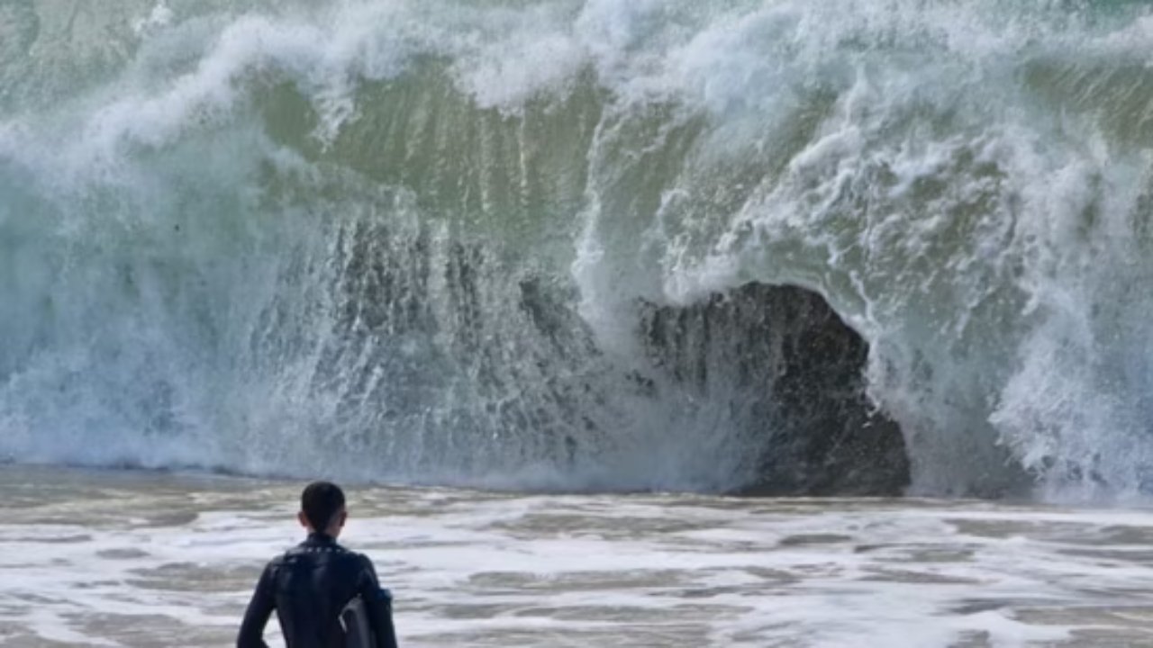
Observed Tsunami Waves (Early Morning, July 30, 2025)
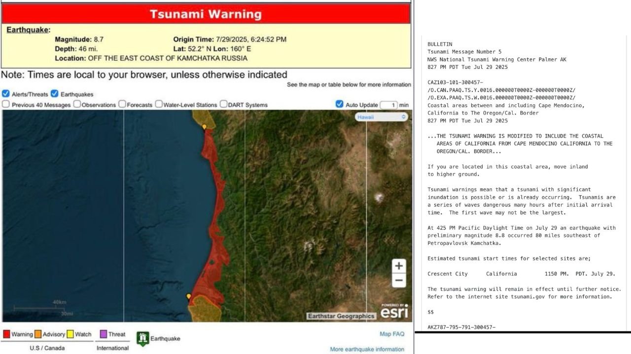
Tsunami waves began impacting the California coast in the early hours of July 30. The NTWC reported observed wave heights of 1.6 feet above tide level in Arena Cove, Mendocino County, at 12:53 a.m., 1.5 feet in Crescent City, Del Norte County, at 12:38 a.m., and 1.4 feet in Monterey at 12:51 a.m. A Tsunami Warning remained in effect for the northern California coast from Cape Mendocino to the Oregon border, with residents urged to move inland to higher ground. The rest of the California coast remained under a Tsunami Advisory.

Regional Alerts and Responses
- Northern California (Del Norte and Humboldt Counties): A Tsunami Warning was issued due to the potential for waves up to 5 feet in Del Norte County, particularly in Crescent City, a historical tsunami hotspot. Residents were urged to evacuate coastal areas immediately.
- Southern California: Los Angeles, Orange, Ventura, and Santa Barbara counties were under a Tsunami Advisory. Beaches were closed, and boaters were advised to move to deeper waters. No evacuation orders were issued for land areas, but residents were urged to avoid beaches, marinas, and harbors. Los Angeles Mayor Karen Bass confirmed that port police and emergency officials were actively responding, urging residents to stay alert and follow instructions.
- San Francisco Bay Area: The advisory covered the Bay Area, with officials in San Mateo and Alameda counties urging residents to stay out of coastal waters. No significant inundation was expected, but dangerous currents were a concern.
- Other Impacts: At least eight flights from Los Angeles International Airport to Hawaii were canceled or diverted due to evacuations in Hawaii.
Tsunami Impacts and Safety Measures
The tsunami generated by the Russian earthquake caused significant impacts elsewhere in the Pacific. In Siberia’s Kamchatka Peninsula, waves of 10 to 13 feet damaged buildings, including a kindergarten. Japan issued evacuation advisories for its east coast, expecting waves up to 10 feet. Hawaii faced waves up to 5 feet, with emergency shelters opened and residents urged to seek higher ground.
In California, the primary concerns were dangerous currents and potential damage to docks and boats. The California Geological Survey’s updated tsunami hazard maps, released in March 2025, highlight the state’s vulnerability, particularly in low-lying areas like Marina del Rey, Long Beach, and Crescent City. These maps indicate that a worst-case distant-source tsunami could cause waves up to 15 feet in Southern California and 32 feet in San Francisco’s Ocean Beach.
Safety Recommendations
- Stay Informed: Monitor NOAA Weather Radio, local radio, television, or mobile alerts (e.g., Wireless Emergency Alerts) for updates. Register for local alert systems like SMC Alert in San Mateo County.
- Evacuation Protocols: In Tsunami Warning areas, move inland to higher ground immediately, preferably on foot to avoid traffic gridlock. In advisory areas, stay out of the water and away from beaches, harbors, and marinas.
- Natural Warning Signs: For local-source tsunamis, which can arrive in minutes, recognize signs like strong earthquakes lasting over 20 seconds, an unusually loud ocean roar, or rapid changes in sea level. Act quickly without waiting for official alerts.
- Prepare in Advance: Familiarize yourself with tsunami hazard zones and evacuation routes using tools like the California Department of Conservation’s interactive maps (conservation.ca.gov/cgs/tsunami/maps). Prepare a “go bag” with at least 72 hours of supplies. Boaters should contact harbor masters for tsunami safety protocols.
- Post-Tsunami Safety: Do not return to low-lying areas until local officials issue an “all clear.” Avoid damaged buildings, fallen power lines, and areas with water accumulation.

Historical Context
California’s tsunami risk is well-documented. The 1964 Alaska earthquake (9.2 magnitude) caused a tsunami that killed 11 people in Crescent City. The 2011 Japan earthquake (9.0 magnitude) resulted in one death in Del Norte County and damaged harbors in Crescent City and Santa Cruz. These events underscore the importance of preparedness, as even distant-source tsunamis can cause significant damage after hours of travel across the Pacific.
Conclusion
The tsunami alerts following the July 29, 2025, earthquake in Russia highlight the ongoing risk to California’s coast. While the observed waves were relatively small, the potential for dangerous currents and localized flooding prompted swift action from officials and residents. By staying informed, preparing evacuation plans, and recognizing natural warning signs, Californians can mitigate the risks posed by future tsunamis.


Post Comment