
Winter Storm To Blanket U.S. With Snow, Ice, And Blizzards: What You Need To Know
- Leave a Comment
- William D
- January 4, 2025

About 45 million people nationwide are expected to be impacted by a significant winter storm that will strike vast swaths of the United States. This strong system is predicted to produce a combination of deadly ice, heavy snow, and severe thunderstorms from Kansas to Maryland, making travel, electricity infrastructure, and everyday activities problematic.
Residents from the Central Plains to the East Coast are preparing for a storm that could seriously disrupt daily life as it moves across the United States this weekend.
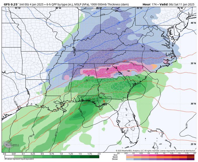
A large portion of the nation has been placed under winter alert, with places like St. Louis, Indianapolis, and Cincinnati feeling the brunt of the storm. While ice accumulations might reach up to 5 inches in certain places, forecasts indicate that snow accumulations could range from 6 to 12 inches in numerous spots.
Whiteout conditions, which could make driving difficult or practically impossible, are anticipated to result from the combination of heavy snow, freezing rain, and strong wind gusts.
Severe weather is predicted to worsen as the storm moves forward, with potentially fatal thunderstorms spreading throughout the South. Widespread interruptions will be caused by the potential for dangerous sleet and freezing rain in affected areas from southern Tennessee to southeast Texas.
The possibility of power disruptions for millions of people is increased by the possibility that ice formation from this winter storm will bring down tree branches and power lines. Significant ice accumulation will also make travel dangerous in parts of the central Appalachians and Ohio Valley.
This winter storm will bring a variety of dangerous circumstances, from dangerous icing in the Northeast to blizzards in the Central Plains, as snow, ice, and severe storms move across the United States.
It is crucial for those in impacted areas to be ready for any effects, since travel delays and power outages are anticipated. Keep abreast of the weather forecast and prepare for a winter storm that may create delays till the beginning of next week.
Early Effects: Northeastern Snow and Mild Weather
Light snow started to fall in several areas of the Northeast on Friday afternoon, signaling the start of a much larger winter storm. Although not particularly heavy, the snow is predicted to reach 1 to 2 inches in places ranging from southern New Jersey to Maryland, which might cause minor disruptions.
This early snowfall is only the beginning; as the storm intensifies, the weekend will see additional severe weather effects. Conditions are predicted to get worse over the next few days as the snow persists, particularly along the Interstate 95 corridor.
The light snow could make the evening commute difficult for motorists along the congested Interstate 95 corridor, which runs from New York to Washington, D.C. There is a greater chance of accidents in this area due to slick roads and decreased visibility caused by snowfall.
Although there won’t be enough snow to force road closures right away, drivers should still use caution because even light snow may make driving dangerous. As the storm moves through the afternoon and evening, slowdowns are anticipated.
Because it affects heavily populated cities like Baltimore, Philadelphia, and the Washington, D.C. metro area, the snow will be more noticeable. Particularly in places where snow has already begun to settle, drivers should be ready for slick roadways.
The snow may cause transportation delays, particularly on key arteries like I-95, and the storm’s reach is considerable. Even while there might not be much snow in certain places, the accumulation could still make driving hazardous.
The first round of weather effects from this ongoing winter storm will be felt throughout the Northeast as the light snow continues to fall into Friday night. much though a 1 to 2 inch snow accumulation might not seem like much, it lays the stage for much more severe winter weather when combined with the anticipated ice and greater snowfall in the days ahead.
It’s crucial for people in impacted areas to keep an eye on local predictions and take the appropriate safety measures to prevent encountering difficult travel conditions.
JUST IN: Winter Storm Warning has been issued for part of the 5 On Your Side area pic.twitter.com/gm4Ssp0qZX
— Scott Connell on KSDK (@scottontvKSDK) January 4, 2025
The Main Event: Severe Weather, Snow, and Ice in the United States.
Winter alerts have been issued for a wide area from Kansas to Maryland as the main event of this significant winter storm develops, and the storm is predicted to get stronger over the weekend. Important cities like St. Louis, Indianapolis, and Cincinnati are expected to have the most snow and ice accumulation.
With forecasts ranging from 6 to 12 inches, these regions are expecting heavy snowfall. In addition to the snow, dangerous ice buildup is anticipated, with up to 5 inches of ice in certain areas. As ice accumulates on power lines and tree limbs, these circumstances will make travel dangerous and may result in power outages.
Strong winds will intensify the effects of the storm in addition to the snow and ice. By Sunday morning, the Central Plains will be seeing blizzard-like conditions due to a combination of heavy snowfall and wind gusts exceeding 35 mph. Whiteout conditions will result from blowing snow and reduced visibility, making driving exceedingly risky and possibly impossible.
Road closures and delayed flights are just two examples of the serious transportation delays that travelers in these areas should expect. Those who disregard the instructions to keep off the roads are particularly at danger of becoming stranded due to the blizzard conditions.
The Central Plains won’t be the only place affected by the storm. Cities like St. Louis, Indianapolis, and Cincinnati will get snow and ice as it heads eastward. There will be hazardous ice buildup of up to 0.25 to 5 inches in certain places in addition to the 6 to 12 inches of snow.
In addition to making driving dangerous, this ice and the strong winds have the potential to bring down power lines, depriving millions of people of electricity. Residents are advised to stay at home and refrain from needless travel because of the storm’s ferocity, which will make travel nearly impossible in certain places.
The storm presents a serious risk to infrastructure and public safety because of the predicted blizzard-like conditions, heavy snow, and ice. From hazardous roadways to extensive power outages, the system will leave a path of devastation as it passes across the Midwest and heads toward the East Coast.
Immediate safety measures should be taken by anyone within the storm’s path, including gathering emergency supplies, remaining inside, and avoiding travel if feasible.
Latest Winter Storm Severity Index: Lots of high impact cities Sunday and Monday. pic.twitter.com/LfN4BiLEhR
— Jim Cantore (@JimCantore) January 4, 2025
About 7 million people in southeastern Texas, Mississippi, and Tennessee are predicted to be impacted by severe thunderstorms as the winter storm continues to travel south. These areas are particularly vulnerable to severe thunderstorms, damaging winds, and hail, which will be exacerbated by dangerous ice and sleet.
Conditions will be particularly dangerous due to the combination of severe weather and cold temperatures, especially for people who are traveling or working outside. As the storm progresses, locals in these locations should continue to be alert and ready for things to change quickly.
Areas in the Ohio Valley and central Appalachians will be at risk from freezing rain and dangerous sleet in addition to violent thunderstorms. This winter weather combination will produce a layer of ice that can swiftly build up and make driving dangerous.
A big worry is ice accumulation on power lines, bridges, and overpasses, which can result in power outages and make mobility practically impossible. Sleet and freezing rain will continue to provide hazardous travel conditions as the storm intensifies, with slick roadways that will increase the likelihood of accidents.
Because even a little quantity of ice accumulation can cause significant disruptions, the storm’s ice threat is especially worrisome. Significant power outages could occur in the Ohio Valley and central Appalachians in locations that receive ice accumulations of 0.25 inches or more.
Power lines and tree branches encased in ice are particularly prone to breaking, causing outages that may persist for many days. Since icy conditions can make driving dangerous and increase the chance of becoming trapped or stranded, travelers should avoid using the roadways in these areas.
Across addition to disrupting daily life, the storm will put thousands of people at risk for hazardous travel conditions and power disruptions due to the combination of sleet, freezing rain, and strong thunderstorms across the South.
To stay safe during this dangerous weather event, residents are advised to avoid driving, gather emergency supplies, and stay informed about weather alerts. The need for readiness in the face of this significant winter storm is underscored by the possibility of power disruptions and the slippery weather.
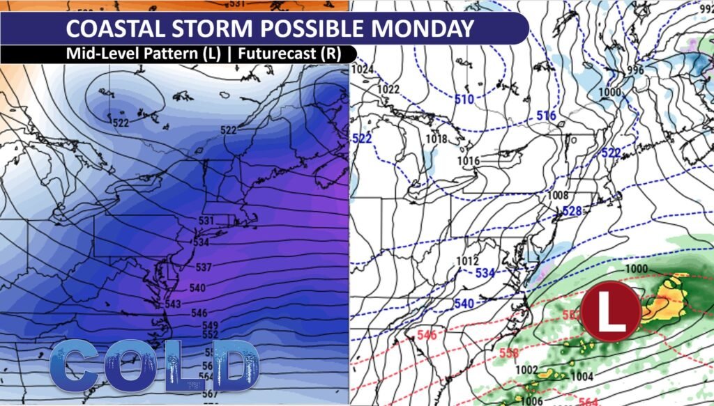
Cities like Pittsburgh, Richmond, Washington, D.C., Baltimore, and Philadelphia may experience major disruptions when the storm reaches its maximum intensity across the Northeast and Mid-Atlantic by Monday. Travel in these large cities will be dangerous all day due to a combination of heavy snow and ice accumulation.
Roads will become slick and visibility will drop when snow and ice fall simultaneously, creating hazardous driving conditions. Those who do not have to travel are encouraged to stay indoors to avoid the dangerous conditions, and commuters should anticipate significant delays.
Snow accumulations in Pittsburgh, Richmond, and Washington, D.C., could be anything from a few inches to more than a foot, and the risk is increased by ice. The roads will be a slick mess due to the heavy snow and freezing rain, which will seriously endanger driving.
Similar difficulties will arise in cities like Baltimore and Philadelphia, where a combination of snow and ice will seriously hamper morning and evening commutes. Because ice builds up on electricity wires and trees, homeowners in these areas should be ready for the prospect of prolonged blackouts.
Areas immediately south of New York City, where the highest snowfall totals are anticipated, will be especially hard hit by the storm. The most snowfall is expected to fall in these areas, with some areas perhaps receiving more than 12 inches.
Travel will be quite challenging due to the combination of the heavy snow and ice, and locals should anticipate extensive interruptions all day long. As the storm moves throughout the Northeast, its full impact will be felt, with snow, ice, and strong winds making driving hazardous or even impossible in some places.
With Pittsburgh, Richmond, Washington, D.C., Baltimore, and Philadelphia all dealing with significant snow, ice, and strong winds, the Northeast and Mid-Atlantic will bear the brunt of the storm as Monday progresses.
These cities’ snow and ice buildup will make travel dangerous and increase the chance of power disruptions. Residents must keep abreast of the storm’s progress and take the appropriate safety precautions during this chaotic winter event, as areas south of New York City will experience the highest snowfall totals.
The northern Plains and Southeast will experience a sharp decrease in temperature as a result of the winter storm’s passage and the subsequent rush of Arctic air from Canada. Much of the United States will experience temperatures substantially below average as a result of this cold air moving over the nation.
The Dakotas and the Deep South will experience some of the coldest temperatures of the season once the storm passes and the icy air settles in. Both locals and visitors will continue to face difficulties as a result of the advent of Arctic air, particularly those who were not prepared for the unexpected cold spell.
Temperatures in the northern Plains are predicted to drop far below freezing, with wind chills making it feel considerably worse in some places. Temperatures in cities like Fargo, Minneapolis, and Sioux Falls will drop far below freezing, so it’s important for people to be warm and take particular care when they’re outside.
In addition to the intense cold, strong winds will produce wind chills that can get dangerously high, raising the possibility of hypothermia and frostbite for anybody who spend a lot of time outside.
The Arctic air will have an impact on the Southeast as well, with below-normal temperatures extending as far south as Florida. Cities like Atlanta, Charlotte, and Birmingham will have exceptionally cold temperatures, with nighttime lows of the 20s and 30s, though not as severe as in the northern Plains.
A protracted period of suffering will result from these cold temperatures as well as the winter storm’s aftereffects. The sudden transition may be difficult for places that are not used to such cold temperatures, which could lead to problems for infrastructure and vulnerable populations.
Millions of people will be impacted by below-normal temperatures that will dominate much of the United States for the majority of the week. The cold will feel much more severe because of the Arctic air’s sharp contrast to the pleasant warmth that many areas had been enjoying before the storm.
From the southeastern Plains to the northern Plains, inhabitants must be ready for prolonged cold weather. As the nation’s weather pattern continues to be shaped by this Arctic blast, wear layers, cover outdoor pipes, and pay attention to local weather forecasts.
It’s critical to keep up with local forecasts as the winter storm strengthens to make sure you’re aware of any changes in the weather and any new warnings in your area. You can stay ahead of the storm’s development and determine when and where the worst conditions are anticipated by keeping an eye on reliable weather sources.
As the storm progresses, this information will also help you make well-informed judgments about whether to change your plans, restock on supplies, or take additional safety measures. Staying informed is essential to ensuring your safety and the safety of those around you, especially if severe weather is affecting vast areas.
It is highly discouraged to travel during the storm’s peak. Travel should be avoided unless absolutely necessary since snow, ice, and strong winds produce dangerous conditions over large areas of the United States. During blizzard conditions, visibility may be almost nonexistent and roads may become inaccessible.
Make sure your car has emergency supplies like blankets, additional clothes, food, water, and a fully charged phone if you have to go. Always make plans in advance, check the state of the roads before leaving, and be ready for any delays or the chance of becoming stranded in inclement weather.
This winter storm poses a serious risk of power disruptions, especially in places where ice is accumulating and winds are high. Making sure you have adequate emergency supplies to last for at least 72 hours is crucial in order to be ready for any power outages. Keep bottled water, non-perishable food, flashlights, batteries, and any prescription drugs you might need on hand.
Make plans to power any electrically dependent medical devices you use in the event of a power outage. In order to maintain connectivity in the event of a power outage, ensure sure your phone and other gadgets are fully charged.
To keep yourself and other people safe, you must take additional care when driving in dangerous situations. To increase visibility, even during the day, lower your speed, extend your following distance, and turn on your headlights. Steer clear of abrupt motions that could cause your car to skid on icy or snowy roads, such as abrupt turns or abrupt brakes.
Instead of attempting to walk to safety in inclement weather, stay in your car, keep the warmth running occasionally, and phone for help if you become stuck. You can contribute to keeping you and your family safe throughout the storm by heeding these safety recommendations and staying alert.
Conclusion:
Heavy snow, dangerous ice, and violent thunderstorms are just a few of the terrible conditions that are predicted to be brought by the winter storm that is spreading over the United States. Significant snow accumulations are expected in regions ranging from Kansas to Maryland, and blizzard-like conditions with wind speeds over 35 mph are predicted for the Central Plains.
Damaged ice accumulation could result in major power outages and hazardous travel conditions in the Ohio Valley and central Appalachians. While the South could face dangerous freezing rain and violent thunderstorms, areas like Pittsburgh, Washington, D.C., and Philadelphia will experience heavy snow and ice as the storm moves east.
Given the storm’s potential to cause disruptions to daily life, it is imperative that you remain aware and take the appropriate safety measures to safeguard your family, your property, and yourself. Avoid traveling when the storm is at its strongest, stay updated with trustworthy weather reports, and stock up on necessary supplies in case of power disruptions.
Take extra precautions to protect your health if you must travel. Millions of people will face difficulties in the days ahead, but you can reduce the risks of this severe winter storm by being ready and careful.